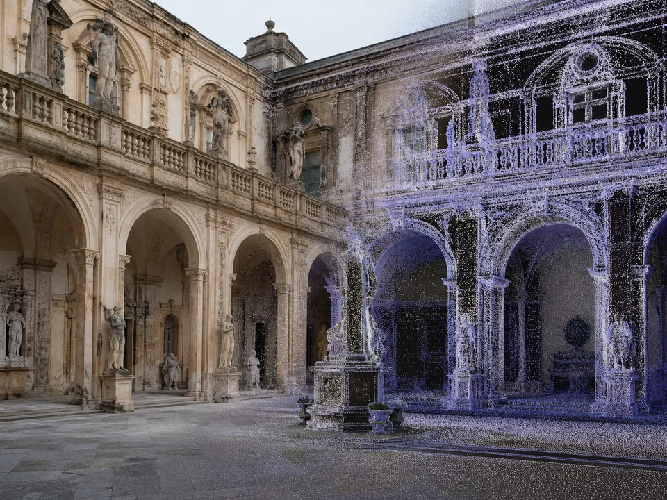
BIM for Historic Buildings: Scan to BIM for Heritage Conservation
Learn how Scan to BIM supports historic building conservation with accurate as-builts, LOD strategy, QA/QC, and workflows used across EU and US heritage projects.
BimzstudioMar 2, 202616 min
historic buildingsheritage BIMScan to BIMconservationlaser scanningLOD
BIM for Historic Buildings: Building Accurate Digital Records for Conservation
Historic buildings rarely behave like modern commercial shells. Walls lean, floors settle, vaults deform, and decorative surfaces hide structural repairs made decades—or centuries—ago. Paper drawings, if they exist, often describe intent rather than the building that actually stands today. Building Information Modeling (BIM), when grounded in high-quality laser scan data, gives conservation teams a measurable, shareable, and durable record of that reality.
This guide explains how BIM for historic buildings works in practice: why heritage projects fail without reliable as-builts, how Scan to BIM methods solve geometry and documentation gaps, what European and U.S. project teams typically require, and how to structure LOD, QA/QC, and deliverables so conservation decisions stay evidence-based.
Heritage projects sit at the intersection of architecture, conservation science, structural engineering, and regulatory oversight. The core problem is not a lack of software—it is a lack of trustworthy geometry and consistent information.
Typical pain points include:
Unknown as-built conditions. Original drawings may be missing, incomplete, or drawn before later alterations.
Irregular geometry. Out-of-plumb walls, twisted floor plates, and deformed roofs break assumptions used in conventional BIM templates.
Fragile fabric. Scaffolding, invasive probes, and prolonged site access can damage finishes or disturb occupancy.
Fragmented stakeholder records. Conservators, surveyors, architects, and contractors often keep separate photo sets, sketches, and spreadsheets.
Scope ambiguity. Teams argue about whether a model should be schematic, detailed, or fabrication-ready without a shared Level of Development (LOD) definition.
Poor reuse. Models built only for one permit package become unusable for later restoration phases.
Without a controlled Scan to BIM process, heritage teams frequently discover conflicts during construction: a new HVAC route that clips a cornice, a structural sistering detail that cannot fit behind historic plaster, or a fire egress path that looks compliant in CAD but fails against real corridor widths.
BIM does not replace conservation judgment. It gives that judgment a spatial foundation. When the point cloud is registered correctly, the model is verified against it, and deviations are documented, every later decision—repair, retrofit, or adaptive reuse—starts from measured reality rather than optimistic assumptions.
Why It Happens
Historic building documentation fails for predictable reasons.
Geometry is non-orthogonal
Modern BIM libraries assume rectangular rooms, consistent wall thicknesses, and level floors. Heritage fabric often includes:
Settled foundations and differential movement
Hand-built masonry with varying coursing
Later infills and partial demolitions
Decorative profiles that cannot be represented by a single wall type
If modelers force historic geometry into “clean” families, the model looks professional while being wrong where it matters most.
Survey methods are mismatched to the asset
A quick handheld capture may be enough for marketing imagery, but it is rarely enough for stone-by-stone conservation planning or structural analysis. Conversely, over-scanning every decorative niche at ultra-high density can produce unmanageable datasets without improving decisions. The failure mode is either under-capture (missing critical surfaces) or unstructured over-capture (no control network, no QA plan).
Information requirements are unclear
Owners may request “a BIM model” without defining:
Ambiguous briefs produce attractive but unusable models.
Site access is constrained
Churches, museums, courthouses, and occupied residences limit scanning windows. Teams rush setups, skip control points, or leave upper vaults and roof voids unscanned. Those gaps reappear as modeling assumptions—and later as field surprises.
Conservation ethics conflict with invasive measurement
Some fabric cannot be touched, painted over, or temporarily cleared. Non-contact laser scanning and photogrammetry are therefore essential, but only if planned with conservation officers and access constraints in mind.
Industry Examples (EU / USA)
Conservation constraints shape LOD and mesh hybrid strategies.
European heritage practice
Across the European Union, heritage work is shaped by national conservation authorities and increasingly by information management expectations aligned with ISO 19650 principles. Common patterns include:
Italy and Southern Europe: Cathedrals, palazzi, and civic monuments often require dense surface documentation for stone conservation. Teams combine terrestrial laser scanning with photogrammetry for façade orthophotos and crack mapping.
Germany and the Netherlands: Adaptive reuse of industrial heritage and brick civic buildings frequently needs coordinated Scan to BIM for MEP insertion into irregular shells.
United Kingdom: Listed building consent processes reward clear evidence of existing conditions. Measured surveys and BIM models support impact assessments for interventions.
Nordic countries: Timber churches and historic timber frames demand careful modeling of deformation and joint conditions rather than idealized framing libraries.
EU projects also tend to emphasize long-term archive value: open formats, documented coordinate systems, and clear separation between observed geometry and interpretive reconstruction.
United States practice
In the U.S., historic work often intersects with the National Park Service’s documentation traditions, State Historic Preservation Offices (SHPOs), and local landmark commissions. Typical scenarios include:
Adaptive reuse of warehouses and mills into housing or offices, where Scan to BIM supports code upgrades, elevator insertions, and fire protection routing.
Campus heritage buildings at universities, where facilities teams need maintainable models linked to asset inventories.
Civic landmarks and courthouses, where security upgrades and accessibility improvements must minimize irreversible alterations.
Seismic retrofit programs on the West Coast, where accurate structural geometry is critical for analysis and detailing.
U.S. delivery often prioritizes Revit-centric collaboration with contractors, while still requiring survey-grade control for large sites. Whether in Brussels or Boston, the technical lesson is the same: heritage BIM succeeds when scanning, modeling, and QA/QC are treated as one workflow—not three disconnected purchases.
Technical Explanation
From point cloud to heritage BIM
A reliable heritage BIM pipeline usually includes:
Control network establishment — survey control tied to a project or national coordinate system.
Laser scanning / photogrammetry capture — terrestrial static scans for interiors and façades; drones or elevated setups for roofs where permitted.
Profiles, connections, service routes against fabric
Selective high detail
Ornament, carved stone, complex vaults
Local mesh / NURBS / high-detail families
Not every cornice needs LOD 400. Many projects succeed with LOD 300 overall plus selective high-detail zones around interventions.
Geometry strategies for irregular fabric
Experienced teams mix methods:
Walls as in-place families or edited wall assemblies where thickness varies significantly
Floor and roof surfaces from scan-derived topography rather than forced single slopes
Mesh for highly sculpted elements linked or referenced into the BIM environment
Point cloud regions retained as live reference for areas not yet modeled
The goal is decision-grade accuracy, not photorealistic completeness everywhere.
QA/QC fundamentals
Heritage QA/QC should verify:
Registration residuals and control residuals
Completeness of coverage in intervention zones
Model-to-cloud deviation statistics by category
Naming, phasing, and metadata consistency
Coordinate system integrity across exports
A model that “looks right” in a shaded view can still be centimeters off—enough to ruin a stone cladding interface or a custom millwork fit.
Data formats and archive value
Common deliverables include:
Registered point clouds (E57, RCS/RCP, LAS/LAZ depending on workflow)
Native BIM models (commonly Revit) and IFC exports
Orthophotos, section cut sheets, and deviation heat maps
Schedules of condition or significance where required
Archive planning matters: heritage projects may reopen years later. Document how the model was built, what was measured versus inferred, and which tolerances were accepted.
Best Practices
Document deviations — do not force perfect rectangles.
Define the conservation question first. Is the model for structural assessment, stone replacement, MEP insertion, accessibility upgrades, or long-term facilities management? Purpose drives LOD and capture density.
Establish survey control early. Do not register a cathedral-scale dataset to an arbitrary interior corner.
Scan for decisions, not for spectacle. Prioritize roofs, foundations interfaces, shafts, and intervention rooms.
Separate observed geometry from reconstruction. Clearly mark reconstructed or hypothesized elements.
Use hybrid modeling. Parametric BIM for coordination; meshes for complex heritage surfaces.
Agree tolerances in writing. Example: ±10–15 mm for primary walls in intervention zones; looser for remote attic massing if justified.
Protect the fabric during capture. Coordinate with conservators on targets, lighting, and access equipment.
Version information carefully. Phasing should distinguish original fabric, later alterations, and proposed work.
Plan for file size and performance. Segment clouds and models by wing, floor, or courtyard.
Require an independent QA/QC pass. Deviation checks should not be optional “if time allows.”
Step-by-Step Solution
Step 1: Stakeholder and information requirements workshop
Bring together owner, conservation architect, structural engineer, MEP designer, surveyor, and BIM lead. Document:
Project goals and intervention locations
Required LOD by element
Coordinate system
Deliverable list and softwares
Access constraints and protected zones
Step 2: Survey design
Create a scan plan showing setups, overlap strategy, control points, and contingency for dark spaces, reflective gilt, or glass. Include safety and heritage protection notes.
Step 3: Field capture
Execute scanning and supporting photography. Log setup IDs, weather/access issues, and any areas intentionally excluded. Capture enough context around intervention interfaces—not only the room being remodeled.
Step 4: Registration and spatial quality review
Register scans, review overlap, check control residuals, and produce a coverage report. Flag voids above ceilings, behind altars, or in roof voids before modeling starts.
Step 5: Modeling kickoff with sample areas
Model a representative bay or room first. Run an early deviation check and calibrate the modeling method before scaling to the full asset.
Step 6: Full model production by priority zones
Model intervention-critical areas first, then supporting context. Keep a live point cloud reference in the authoring environment.
Step 7: Discipline coordination (if retrofit is planned)
Federate architecture, structure, and MEP. Clash-check new systems against historic fabric and against each other. Resolve with conservation constraints documented.
Step 8: Formal QA/QC and client review
Deliver deviation maps, issue logs, and a modeling statement describing assumptions. Walk the client through critical sections overlaid on the cloud.
Step 9: Handover and archive package
Provide native files, exchanges, cloud references, and a short data dictionary so future teams can trust and extend the model.
Case Study
Project type: Historic civic building adaptive reuse (European city center) Challenge: Insert modern climate control and accessibility upgrades into a nineteenth-century masonry building with deformed floor plates and richly detailed public halls. Existing drawings conflicted with on-site observations.
Approach:
A survey control network was established and tied to the municipal coordinate reference.
Static terrestrial scanning covered basements, public halls, office wings, and roof voids during approved night and weekend windows.
Photogrammetry supplemented ornate façade zones for orthographic documentation.
The Scan to BIM team modeled primary architecture and structure to LOD 300, with selective higher detail at stair interventions and plant-room tie-ins.
MEP routes were coordinated against the verified fabric model, not against cleaned “idealized” walls.
QA/QC included category-based deviation sampling and a federated clash review focused on heritage interfaces.
Outcome: The design team avoided multiple late redesigns in the ceremonial halls, documented irreversible-work risks for the conservation authority, and handed facilities staff a maintainable as-built baseline for future phases. The decisive factor was not software brand—it was disciplined registration, clear LOD scoping, and model-to-cloud verification before coordination.
(Composite case based on typical EU heritage retrofit patterns; project specifics vary by asset and authority requirements.)
Common Mistakes
Cleaning geometry too aggressively. Squaring every wall destroys the conservation value of the model.
One LOD for everything. Over-modeling ornament wastes budget; under-modeling intervention zones creates risk.
Skipping control. Beautiful clouds that float in local coordinates become painful to reuse.
Treating mesh capture as BIM. A textured mesh is documentation; BIM requires structured elements and information for coordination and FM.
Ignoring roofs and voids. Many failures originate above ceilings and in attics.
No deviation report. Without QA/QC, nobody can defend model accuracy to reviewers or fabricators.
Late stakeholder alignment. If conservation officers see the model only at submission, expect painful revisions.
Unclear ownership of assumptions. Modelers silently fill gaps; later users treat those guesses as measured fact.
Expert Tips
Write a “measured vs. interpreted” rule in the BEP. Every element category should state whether geometry is scan-verified, partially verified, or inferred.
Use section boxes relentlessly. Heritage errors hide in thickness and alignment, not in pretty 3D views.
Capture condition while you scan. Even simple photo links or condition codes multiply the model’s value for conservators.
Model for the next ten years. Owners often return for phased upgrades; naming and coordinates should survive staff turnover.
Protect performance. Worksets/containers by wing and discipline keep large heritage models usable.
Calibrate scanners and workflows to materials. Dark wood, polished marble, and stained glass each create different noise and dropout behavior.
Budget a second visit. Heritage sites almost always reveal one critical unscanned pocket after the first registration review.
Heritage BIM is moving toward richer digital twins, but the foundation remains accurate reality capture.
Selective digital twins: Linking environmental sensors and maintenance records to verified geometry for vulnerable assets.
AI-assisted classification: Faster separation of walls, vaults, and MEP clutter in dense clouds—still requiring human QA/QC.
Better hybrid deliverables: Seamless combination of BIM objects, meshes, and Gaussian/nerf-style visualization for public engagement without sacrificing engineering rigor.
Stronger information standards: Clearer alignment with ISO 19650-style information containers for cultural heritage projects.
Conservation-specific metadata schemas: Significance, material vulnerability, and intervention history becoming first-class model data.
Mobile + static fusion: Faster indoor coverage with backpack/mobile systems, anchored by static scan control where tolerances are tight.
The teams that will lead this space are those who treat Scan to BIM as measured engineering—not as a visualization add-on.
FAQ
1. Is BIM appropriate for irregular historic buildings?
Yes—if you accept hybrid methods. Parametric BIM handles coordination and documentation; meshes and point clouds handle complex surfaces. Forcing every carved element into a generic family is what fails, not BIM itself.
2. What LOD should we request for a heritage Scan to BIM project?
Most conservation and adaptive reuse projects perform well at LOD 300 for primary architecture/structure, with selective higher detail where interventions, fabrication, or stone replacement require it. Define LOD by category in a matrix.
3. How accurate does a historic building BIM model need to be?
Accuracy should match decisions. Intervention interfaces often need centimeter-level or better agreement with the point cloud. Remote context may tolerate more. Agree tolerances and prove them with deviation checks.
4. Can we use only Matterport-style capture for heritage BIM?
Consumer-oriented reality capture can support visualization and early planning, but engineering-grade heritage BIM usually requires survey control, higher-accuracy laser data, and formal QA/QC—especially for structural or fabrication interfaces.
5. Should every decorative feature be modeled?
No. Model what affects conservation decisions, coordination, or documentation obligations. Leave other areas as referenced cloud or annotated orthophotos unless the brief explicitly requires full ornamental BIM.
6. What deliverables matter most to conservation authorities?
Authorities vary, but clear existing-condition evidence, coordinated proposals, and transparent documentation of interventions are universal. Orthophotos, sections through the verified model, and statements of impact supported by accurate geometry are typically more persuasive than unvalidated 3D views.
7. How do EU and U.S. heritage BIM needs differ?
Process and approval culture differ, but technical needs converge: reliable as-builts, controlled coordinates, appropriate LOD, and traceable QA/QC. EU projects may emphasize archival openness and conservation doctrine; U.S. projects often emphasize contractor collaboration and code-driven retrofits.
8. When should we bring in a Scan to BIM specialist?
Before the first full design freeze—ideally during survey planning. Fixing a poorly scoped capture after modeling has started is far more expensive than planning LOD, tolerance, and coverage up front.
Summary
BIM for historic buildings works when it begins with measured reality. Laser scanning and careful Scan to BIM modeling replace conflicting drawings with a verifiable spatial record. Success depends on clear purpose, survey control, hybrid modeling for irregular fabric, explicit LOD, and rigorous QA/QC against the point cloud. European and U.S. heritage teams face different approval cultures, but they share the same technical requirement: decisions must rest on the building that exists, not the building someone once drew.
Avoid over-cleaning geometry, under-defining information requirements, and skipping deviation analysis. Do those things well, and the model becomes a long-term conservation asset rather than a one-off visualization.
Work with Bimzstudio on Heritage Scan to BIM
If you are planning conservation, adaptive reuse, or retrofit work inside a historic asset, Bimzstudio can help you turn laser scan data into decision-grade BIM. Our team delivers Scan to BIM models with defined LOD, disciplined QA/QC against the point cloud, and coordination-ready outputs for EU and U.S. project workflows—so architects, engineers, and conservation stakeholders can design against verified existing conditions.
Share your building type, scan status, and intervention goals, and we will recommend a practical LOD matrix, tolerance strategy, and delivery package aligned to your heritage scope.