
Reduced Drift Risk
Target- and cloud-based registration with overlap checks keeps floors and grids from drifting across setups.
Point Cloud Processing · Survey Alignment
We align multi-station laser scans into a single, control-referenced point cloud — with unified coordinates, verified overlap and documentation your modelers and surveyors can trust.


Problem Statement
Individual scan setups drift, overlap inconsistently and sit in local coordinates. Modeling against unregistered clouds produces misaligned floors, skewed grids and unreliable deviation checks.
Our Solution
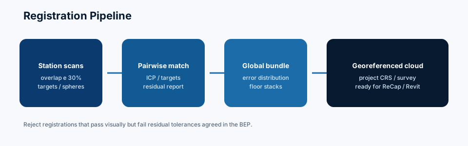
We align multi-station scans using targets, overlap and control points, unify coordinate systems and units, and deliver a registered cloud ready for modeling, QA and stakeholder review. Point cloud workflows can accommodate data captured with scanners such as Leica BLK360 and Leica RTC360, depending on the project data supplied.
Multi-Station Alignment
Control-Point Verified
Unified Coordinates
Modeling-Ready Export
Benefits
Registration that removes coordinate risk before a single BIM element is placed.
Target- and cloud-based registration with overlap checks keeps floors and grids from drifting across setups.
Clouds are transformed to your survey control, shared coordinates or project base point as specified.
Error metrics, control residuals and setup maps document how the cloud was aligned.
Exports in E57, RCP/RCS or agreed formats so Revit, Archicad and ReCap open cleanly.
Most registration packages return in 2–5 business days depending on station count and control quality.
Workflow
A disciplined registration workflow from raw setups to a single reference cloud.
We confirm scanner type, target strategy, control network and required export formats.
Individual setups are inventoried for coverage gaps, density and obvious movement artifacts.
Registration method, control hierarchy and coordinate transformation are agreed before processing.
Setups are aligned using targets, overlap and control points, then unified into one cloud.
Residuals, slice checks and overlap visuals confirm the cloud meets agreed tolerances.
Registered cloud, report and optional cleanup package are delivered for modeling kickoff.
Methodology
Practical definitions, limitations and commercial factors — written so they stay true from one project to the next.
Registration aligns multiple scan setups into one coordinated point cloud so modeling, deviation checks and drawings share a single coordinate system.
A poorly registered cloud cannot produce a reliable Scan-to-BIM model. Floor-to-floor drift, skewed grids and false clashes usually start in registration, not in Revit or Archicad. Modeling should wait until the reference cloud is fit for the agreed tolerance.
Unregistered or loosely aligned setups in formats such as E57, PTX or scanner-native projects, plus any survey control. Cleanup of noise can be scoped with registration or separately.
Next step
If this service matches your brief, request a scoped proposal. Commercial terms depend on the project requirements you submit.
Deliverables
Everything your modeling or survey team needs to proceed with confidence.

Unified E57, RCP/RCS or agreed format ready for BIM authoring.
Setup map, residual statistics and coordinate system documentation.
Survey control references and transformation parameters used.
Visual slice and overlap checks supporting the numeric residuals.
LOD Support
LOD is specified by category and project stage. Not every engagement requires every LOD.

LOD 200
Generalized systems and approximate quantities for schematic design coordination.
LOD 300
Accurate size, shape, location and orientation suitable for design development.
Software Used
Industry-standard authoring and QA software, chosen to match how your team already works.
Autodesk ReCap Pro
Indexing, registration and RCP/RCS delivery.
Leica Cyclone
Survey-grade registration for Leica workflows.
FARO Scene
FARO project registration and export.
CloudCompare
Independent alignment checks and diagnostics.
Industries
The same coordinated, QA-checked modeling pipeline, tailored to each sector's compliance and detail requirements.
 London · New York · EU · USA
Coordinated Revit and Archicad delivery for HQ campuses, towers, and mixed-use schemes across London, New York, and major EU and US business districts.
 Stockholm · EU · USA
High-detail clinical BIM for hospitals and medical campuses in Stockholm, Northern Europe and the United States, built around live-operation constraints.
 EU · USA
Process-plant and manufacturing models with constructible MEP outcomes for facilities across Europe and the United States.
 EU · USA
Scan-to-BIM digital twins for bridges, corridors, and airside assets supporting civil teams across Europe and the United States.
FAQ
Answers to what teams most often ask before starting a scan registration project.
Leica, FARO, Trimble and other terrestrial scanners exporting standard formats — contact us if you use a specialty system.
Control improves absolute accuracy. Relative registration is possible without it, but we recommend control for multi-building or site-tied work.
Yes. We routinely merge interior and exterior stations into a single site-referenced cloud.
Related Services
Pair this service with adjacent capabilities for a complete Scan to BIM, coordination and handover pipeline.

Point Cloud Processing
Noise removal, classification and segmentation so modelers work from clean data.
Explore Point Cloud Cleanup
Scan to BIM
Scan-to-BIM: convert registered point clouds into coordinated BIM models at the LOD your project actually needs.
Explore Point Cloud to BIM
Scan to BIM
Point Cloud to Revit: native Revit BIM authored against a registered cloud, organized to your project template where provided.
Explore Point Cloud to Revit
Scan to BIM
Point Cloud to Archicad: native PLN models from a registered cloud — a Scan-to-BIM delivery route for Graphisoft offices.
Explore Point Cloud to Archicad
Scan to BIM
Verified as-built BIM models reflecting installed conditions for handover and FM.
Explore As-Built BIM
MEP & Coordination
Multi-discipline clash detection and coordination before construction starts.
Explore Clash DetectionUpload sample setups or a project brief and receive a registration proposal within 24 hours.
Tolerances are agreed per project. Typical building registrations target millimeter-to-centimeter residuals depending on method and range.
Cleanup can be bundled — see Point Cloud Cleanup — or delivered as a follow-on package.
Contact
Reach out directly, or upload your point cloud above to request a scoped proposal based on your project brief. We typically reply after a clear brief.
Remote delivery
Europe and United States AEC teams

Language
