
Geringeres Drift-Risiko
Target- und cloud-basierte Registration mit Overlap-Prüfungen hält Geschosse und Raster über Setups stabil.
Point-Cloud-Verarbeitung · Vermessungsausrichtung
Wir richten Multi-Station-Laserscans in eine einzige, control-referenzierte Point Cloud aus — mit einheitlichen Koordinaten, geprüftem Overlap und Dokumentation, der Modellierer und Vermesser vertrauen können.


Problem Statement
Einzelne Scan-Setups driften, überlappen ungleichmäßig und sitzen in lokalen Koordinaten. Modellierung gegen unregistrierte Clouds erzeugt versetzte Geschosse, schiefe Raster und unzuverlässige Abweichungsprüfungen.
Our Solution
Wir richten Multi-Station-Scans über Targets, Overlap und Control Points aus, vereinheitlichen Koordinatensysteme und Einheiten und liefern eine registrierte Cloud für Modellierung, QA und Stakeholder-Review. Workflows können Daten von Scannern wie Leica BLK360 und Leica RTC360 aufnehmen, abhängig von den gelieferten Projektdaten.
Multi-Station-Ausrichtung
Control-Point-geprüft
Einheitliche Koordinaten
Modellierbereiter Export
Benefits
Registration, die Koordinatenrisiko entfernt, bevor das erste BIM-Element gesetzt wird.
Target- und cloud-basierte Registration mit Overlap-Prüfungen hält Geschosse und Raster über Setups stabil.
Clouds werden auf Ihre Survey Control, Shared Coordinates oder den Projektbasispunkt transformiert.
Fehlermetriken, Control Residuals und Setup-Karten dokumentieren die Ausrichtung.
Exporte in E57, RCP/RCS oder vereinbarten Formaten, damit Revit, Archicad und ReCap sauber öffnen.
Typisch 2–5 Werktage, abhängig von Stationenzahl und Control-Qualität. Typische Spanne, kein SLA und kein garantierter Termin.
Workflow
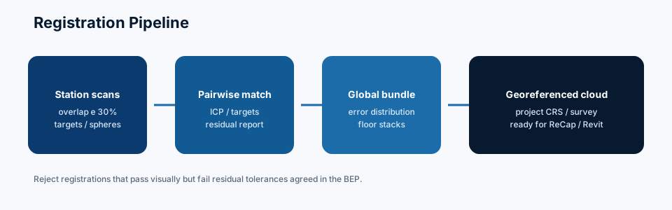
Ein disziplinierter Registrierungsworkflow von Roh-Setups zu einer einzigen Referenz-Cloud.
Wir bestätigen Scannertyp, Target-Strategie, Control-Netz und geforderte Exportformate.
Einzelne Setups werden auf Abdeckungslücken, Dichte und Bewegungsartefakte inventarisiert.
Registrierungsmethode, Control-Hierarchie und Koordinatentransformation werden vor der Verarbeitung vereinbart.
Setups werden über Targets, Overlap und Control Points ausgerichtet und zu einer Cloud vereinheitlicht.
Residuals, Slice-Prüfungen und Overlap-Visuals bestätigen, dass die Cloud die vereinbarten Toleranzen erfüllt.
Registrierte Cloud, Report und optionales Cleanup-Paket für den Modellierungsstart.
Methodology
Practical definitions, limitations and commercial factors — written so they stay true from one project to the next.
Registration aligns multiple scan setups into one coordinated point cloud so modeling, deviation checks and drawings share a single coordinate system.
A poorly registered cloud cannot produce a reliable Scan-to-BIM model. Floor-to-floor drift, skewed grids and false clashes usually start in registration, not in Revit or Archicad. Modeling should wait until the reference cloud is fit for the agreed tolerance.
Unregistered or loosely aligned setups in formats such as E57, PTX or scanner-native projects, plus any survey control. Cleanup of noise can be scoped with registration or separately.
Next step
If this service matches your brief, request a scoped proposal. Commercial terms depend on the project requirements you submit.
Deliverables
Alles, was Ihr Modellierungs- oder Vermessungsteam braucht, um weiterzugehen.

Einheitliches E57, RCP/RCS oder vereinbartes Format, bereit für BIM-Authoring.
Setup-Karte, Residualstatistiken und Koordinatensystemdokumentation.
Survey-Control-Referenzen und verwendete Transformationsparameter.
Visuelle Slice- und Overlap-Prüfungen zu den numerischen Residuals.
LOD Support
LOD is specified by category and project stage. Not every engagement requires every LOD.

LOD 200
Generalized systems and approximate quantities for schematic design coordination.
LOD 300
Accurate size, shape, location and orientation suitable for design development.
Software Used
Industry-standard authoring and QA software, chosen to match how your team already works.
Autodesk ReCap Pro
Indexing, registration and RCP/RCS delivery.
Leica Cyclone
Survey-grade registration for Leica workflows.
FARO Scene
FARO project registration and export.
CloudCompare
Independent alignment checks and diagnostics.
Industries
The same coordinated, QA-checked modeling pipeline, tailored to each sector's compliance and detail requirements.
 London · New York · EU · USA
Coordinated Revit and Archicad delivery for HQ campuses, towers, and mixed-use schemes across London, New York, and major EU and US business districts.
 Stockholm · EU · USA
High-detail clinical BIM for hospitals and medical campuses in Stockholm, Northern Europe and the United States, built around live-operation constraints.
 EU · USA
Process-plant and manufacturing models with constructible MEP outcomes for facilities across Europe and the United States.
 EU · USA
Scan-to-BIM digital twins for bridges, corridors, and airside assets supporting civil teams across Europe and the United States.
FAQ
Answers to what teams most often ask before starting a scan registration project.
Leica, FARO, Trimble und andere terrestrische Scanner mit Standardformaten. Workflows können Daten von Scannern wie Leica BLK360 und Leica RTC360 aufnehmen, abhängig von den gelieferten Projektdaten. Kontaktieren Sie uns bei Spezialsystemen.
Control verbessert die absolute Genauigkeit. Relative Registration ist ohne möglich, aber für Mehrgebäude- oder standortgebundene Arbeit empfehlen wir Control.
Ja. Wir führen Innen- und Außenstationen regelmäßig in eine standortreferenzierte Cloud zusammen.
Toleranzen werden je Projekt vereinbart. Typische Gebäuderegistrierungen zielen auf Millimeter- bis Zentimeter-Residuals, abhängig von Methode und Distanz.
Cleanup kann gebündelt werden — siehe Point Cloud Cleanup — oder als Folgepaket. Nach der Registration sind typische nächste Schritte Point Cloud to BIM oder Point Cloud to Revit.
Related Services
Pair this service with adjacent capabilities for a complete Scan to BIM, coordination and handover pipeline.

Point Cloud Processing
Noise removal, classification and segmentation so modelers work from clean data.
Explore Point Cloud Cleanup
Scan to BIM
Scan-to-BIM: convert registered point clouds into coordinated BIM models at the LOD your project actually needs.
Explore Point Cloud to BIM
Scan to BIM
Point Cloud to Revit: native Revit BIM authored against a registered cloud, organized to your project template where provided.
Explore Point Cloud to Revit
Scan to BIM
Point Cloud to Archicad: native PLN models from a registered cloud — a Scan-to-BIM delivery route for Graphisoft offices.
Explore Point Cloud to Archicad
Scan to BIM
Verified as-built BIM models reflecting installed conditions for handover and FM.
Explore As-Built BIM
MEP & Coordination
Multi-discipline clash detection and coordination before construction starts.
Explore Clash DetectionBeschreiben Sie Setups, Control und Exportformate. Wir antworten mit einem scoped Registration-Proposal.
Contact
Reach out directly, or upload your point cloud above to request a scoped proposal based on your project brief. We typically reply after a clear brief.
Remote-Lieferung
Europe and United States AEC teams

Sprache
