Learn why laser scanning fails on real sites—planning, materials, registration, and process gaps—and how to prevent failed Scan to BIM capture.
BimzstudioApr 22, 202512 min
laser-scanningLiDARTLSScan to BIMsurvey failureregistration
Why Laser Scanning Fails
Laser scanning rarely “fails” because the instrument is broken. It fails because the job was under-specified, the site fought the physics, the registration was rushed, or success was defined as pretty RGB instead of measurable geometry. This article explains the real failure modes behind terrestrial and mobile laser scanning on building projects—especially when the end goal is Scan to BIM for Europe and USA renovation work.
Scanner accuracy claims are not the same as project accuracy.
Stakeholders buy laser scanning expecting certainty. Marketing sheets from established vendors (Leica, Faro, Trimble, and others) correctly describe instrument precision under controlled conditions. Sites are not controlled conditions. Failure, in practice, means one or more of:
The dataset cannot support the stated LOD
Registration residuals exceed the accuracy budget
Critical areas are missing and cannot be revisited easily
The cloud cannot be georeferenced to project control
Delivery is so late or so heavy that the design team abandons it
The model built from the scan creates false confidence
Failure type
Visible sign
Business impact
Coverage failure
Holes in shafts/plant
Redesign risk, rescan cost
Accuracy failure
Seams, drift
Wrong prefab, clashes
Usability failure
Unopenable files
Schedule slip
Scope failure
Wrong things captured
Claim disputes
Process failure
No QA trail
Untrusted deliverable
Scanning fails upstream of modeling more often than modelers admit. Blaming Revit will not fix a poorly planned capture.
Why It Happens
Occlusion, reflectivity, and schedule windows break naive scan plans.
1. Ambiguous purpose
“Scan the building” is not a method statement. Without knowing whether the scan supports space planning, demolition, or spool fabrication, teams choose wrong density, wrong instrument class, and wrong time on site.
2. Physics of materials and environment
Laser pulses need a cooperative return. Specular metal, glass, wet asphalt, black insulation, and fog/dust degrade data. Multipath around pipes creates systematic bias that looks like geometry but is not.
3. Access and schedule theater
Clients approve scanning during operations, then restrict rooms, forbid ladder use, and limit night work. The scan completes “on time” with silent gaps.
4. Weak control strategy
Targets on paper, control on hope. Indoor-only jobs skip tying floors together. Outdoor façades ignore wind and scaffold movement.
5. Over-reliance on auto-registration
Feature-poor corridors, repetitive parking decks, and glass atriums fool cloud-to-cloud algorithms. A green checkmark is not a certified network.
6. Wrong platform choice
Using only SLAM handhelds for high-accuracy plant rooms—or only slow TLS for kilometers of corridor—creates either inaccurate or economically failed projects.
7. No acceptance test
If nobody defined how failure is measured, every cloud can be argued as “good enough” until a steel fabricator proves otherwise.
Industry Examples
US airport terminal retrofit. Scanning was scheduled between flights. Security queues shortened setups. Boarding-bridge interfaces were under-scanned. Downstream BIM for jet-bridge foundations suffered. Failure was planning, not scanner brand.
Dutch process skid replacement. Reflective stainless and dense pipe racks produced noisy cylinders. The team treated first-pass data as final. Prefab clashes followed. A second night with better angles and targets would have been cheaper than field trim.
French hotel façade survey for permit. Rain intermittent; upper cornices incomplete. Photogrammetry was supposed to fill gaps but lacked control. The “hybrid” deliverable failed municipal accuracy expectations.
Chicago high-rise riser modernization. Elevator shaft scanning without intermediate stops left spiral gaps. Modelers extruded risers from partial evidence. Later opening of shaft walls showed offsets. Classic occlusion failure sold as complete Scan to BIM.
Technical Explanation
Failures often appear first as registration residuals nobody checked.
Instrument capability vs. project accuracy budget
An instrument might offer millimeter-level range noise at short range. Project accuracy must include:
Instrument noise
Setup stability
Registration residual
Georeferencing residual
Modeling interpretation (if Scan to BIM)
Temperature effects on long steel / large structures (special cases)
If fabrication needs ±5 mm at a flange, your scanning + registration + modeling chain must be designed for that—not merely “high resolution.”
Line of sight is non-negotiable
Laser scanning does not see through objects. Ceiling clouds, cable trays, and duct banks hide what renovation teams often need most. Failure is promising X-ray vision.
Registration as a survey network
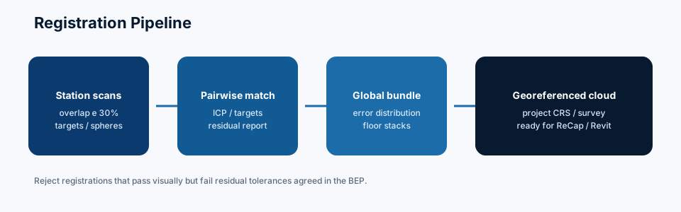
Think like control surveying. Targets are stations of known relative geometry. Cloud-to-cloud is like resection with millions of observations—but still needs geometry strength. Long, thin networks without cross-bracing drift. Details: Scan Registration Challenges.
Mobile mapping drift
SLAM systems are excellent productivity tools. They also accumulate drift without loop closures or periodic absolute control. Treating SLAM accuracy as TLS accuracy is a category error—and a common reason “laser scanning failed” on jobs that were never TLS jobs.
Environmental failure modes
Condition
Effect
Mitigation
Rain / fog
Noise, range loss
Wait / cover / reschedule
Direct sun on dark façades
Mixed imaging, some ranging stress
Time of day planning
Vibration (operating plant)
Blurred stations
Shorter scans, better setups
Crowds
Ghost points
Off-hours, filtering
High glass ratio
Holes, false ranges
Angles, targets, tape notes
Data management failure
Cards fill, batteries die, naming collapses, and stations are overwritten. These are operational failures with the same impact as bad ranging. Trimble/Leica/Faro ecosystems all assume disciplined field procedures—software cannot repair missing stations.
Best Practices
Write a purpose statement tied to LOD and tolerance before mobilizing.
Choose hybrid capture deliberately: TLS for critical plant, mobile for circulation.
Design a control and target network on plan drawings first.
Require coverage heatmaps as a field exit deliverable.
Forbid silent exclusions—locked doors go on a list the same day.
QA registration before leaving town when travel costs are high.
Separate “scan complete” from “cloud accepted.”
Match staffing to site complexity—one person rushing a hospital at night fails predictably.
Calibrate / check instruments per company QA policy; keep logs.
Align commercial terms with rescan triggers so failure is manageable, not catastrophic.
Prevent recurrence: residual thresholds, coverage %, control RMSE.
Step 10 — Communicate outcomes
Owners respect clear failure analysis more than defensive blame. Tie next steps to schedule milestones.
Case Study
Project: University science wing, Midwest USA Intent: Scan to BIM for HVAC replacement in occupied labs What failed: First campaign used a mobile scanner for speed. Plant rooms were “captured” through open doors from corridors. Pipe racks farther than a few meters were sparse and noisy. Registration looked fine along corridors. The mechanical engineer rejected the model when flange-to-flange dimensions could not be trusted for prefabricated headers.
Recovery: A second campaign with terrestrial scanners, targets on rack steel, and night access into each plant room. Two additional days on site. The mobile corridor cloud was retained for architectural context. Prefab proceeded.
Root cause in one line: Wrong instrument class for the decision being made—not “laser scanning doesn’t work.”
Common Mistakes
Equating scanner brochure accuracy with deliverable accuracy
No target network on large floorplates
Scanning reflective plant the same way as drywall offices
Leaving registration QA to the modeling firm alone
Declaring success based on fly-through videos
Ignoring weather for exterior campaigns
Underestimating file delivery and indexing time
Mixing multiple crews’ naming conventions
Promising complete shafts without intermediate setups
Starting demolition before cloud acceptance
Expert Tips
Ask “what decision fails if we are wrong by 20 mm?” That answers whether you need TLS.
Photograph every locked door with timestamp for the exclusion log.
Carry spare targets and batteries like you carry spare blades on a cutter—non-negotiable.
Run a 10-minute registration smoke test after the first hour on unfamiliar sites.
For glass atriums, put targets on slabs and columns, not only relying on façade features.
Treat scaffold movement as a dynamic survey problem; do not assume static geometry.
Read intensity when RGB looks fine—geometry problems hide in mono sometimes.
Contract language: “cloud acceptance workshop” as a paid milestone.
If using drones/photogrammetry outdoors, still tie to the same control as TLS.
Never let marketing RGB colorization drive overnight deadlines at the expense of registration.
Failure Modes by Project Type
Different building types fail for different reasons. A method statement that works for an empty warehouse will fail in a live hospital. Use the patterns below when writing proposals and BEPs.
Offices and fit-outs
Failures are usually coverage and ceiling-void access, not instrument noise. Occupied floors hide the MEP that renovation needs most. Scanning only the finished ceiling plane is a predictable failure if the project is an HVAC replacement. Negotiate tile removal samples or night interstitial access before promising LOD 350 MEP.
Healthcare and labs
Access windows are short; infection control and security constrain setups. Failure looks like complete corridor clouds with empty plant rooms. Mobile mapping helps circulation; TLS must still own critical mechanical spaces. See also renovation BIM strategy in BIM for Renovation Projects.
Industrial and process
Reflective metals, dense racks, heat, and vibration dominate. Brochure accuracy collapses without angle planning and targets on steel. Prefab tie-ins fail when teams accept first-pass noisy cylinders as truth.
Heritage and civic
Irregular masonry is not a scanner failure—forcing planar BIM too early is. Failure here is often contractual: promising LOD 400 carved ornament from a rapid TLS pass. Scope mesh or higher detail only where interventions land.
Exterior facades and campuses
Weather, traffic, GNSS multipath near towers, and incomplete elevation coverage cause gaps at cornices and recesses. Photogrammetry hybrids help only when control is shared. Absolute CRS mistakes show up when facade brackets meet surveyed slab edges.
Contract Language That Prevents Silent Failure
Write cloud acceptance as a milestone with measurable tests: coverage percentage by zone, residual limits, control RMSE, and a signed exclusions list. Separate scan complete (field work finished) from cloud accepted (fit for modeling). Pay schedules that fund modeling before acceptance incentivize failure. Reference method statements naming instrument class (TLS vs mobile) for each zone type.
buildingSMART and ISO 19650 do not replace survey QA, but they give you a place to hang acceptance criteria inside the information management process. Put registration reports in the CDE as controlled documents, not chat attachments.
Hold a lessons-learned meeting before the next wing or floor.
Crew and logistics factors
Understaffed night shifts, missing spare batteries, unlabeled cards, and improvised station naming cause failures as often as ranging physics. Treat field operations with the same seriousness as registration math. A competent second person for target placement and logging dramatically reduces silent gaps.
Future Trends
Scanning hardware will keep getting faster (higher PRR, better imaging, tighter SLAM). Failure modes will shift from “too slow” to “too confident.” AI will auto-flag holes and noise, which helps—but absolute accuracy for prefab will still need survey discipline, control networks, and human acceptance.
ISO 19650-aligned clients will increasingly require documented capture methods in the BEP. That is healthy: it makes failure detectable early. Digital twin programs will also punish incomplete scans because asset location errors propagate into operations software.
buildingSMART-centric openBIM delivery does not remove the need for good ranging; it only changes how accepted geometry is exchanged.
Checklist: Is This Campaign Likely to Fail?
Use this pre-mobilization risk checklist. Three or more “no” answers means redesign the method before scanning.
Is the purpose tied to explicit LOD and tolerances?
Is instrument class matched to the tightest decision (TLS vs mobile)?
Is access confirmed in writing for critical rooms?
Is a control/target network designed on plan?
Is registration QA scheduled before modeling starts?
Is weather contingency included for exteriors?
Is an exclusions process agreed with the client?
Is file delivery/indexing time in the schedule?
Is a rescan allowance commercially acknowledged?
Is someone named as acceptance authority?
Scanning fails less often from exotic physics than from unanswered items on this list. Fix the list, and most “LiDAR doesn’t work” stories disappear.
Frequently Asked Questions
Does brand choice cause most failures?
No. Process, access, and registration cause more failures than choosing Leica vs Faro vs Trimble. Brand ecosystems matter for software familiarity, not magic accuracy.
Can a failed scan be fixed in software?
Sometimes registration and cleaning help. Missing line-of-sight data cannot be invented safely for high-LOD MEP.
Is mobile scanning more likely to fail?
It fails when used outside its accuracy envelope. Inside corridors for LOD 200–300 architecture, it often succeeds brilliantly.
Who owns failure—client or scanning firm?
Shared. Clients own access and scope clarity; scanning firms own method and QA. Contracts should say so.
How do I know scanning failed before modeling?
Coverage maps, control checks, residual reports, and vertical sections. Do not wait for Revit drama.
Are indoor scans immune to weather?
Mostly, but HVAC drafts, dust, and temperature gradients can still matter for sensitive work. Exterior links still face weather.
Should we always rescan after failure?
Rescan critical zones. Non-critical gaps can be documented if the LOD matrix allows unknowns.
Laser scanning fails when purpose, physics, access, control, registration, and acceptance are neglected—not because LiDAR is unreliable. Define the decision, pick the right platform mix, build a real network, QA before modeling, and treat exclusions as first-class data. That is how Europe and USA renovation teams turn scanning from a risk into a reliable as-built foundation.
Call to Action
Bimzstudio works from well-qualified clouds to deliver Scan to BIM with accurate modeling, fast turnaround, and QA/QC across LOD 100–500 for EU and USA projects. If you need the modeling side handled with production discipline, see Point Cloud to BIM and Point Cloud to Revit.