
Scan to CAD (As-Built Documentation)
Scan to CAD (As-Built Documentation): For projects requiring 2D deliverables, we extract precise as-built floor plans, elevations, sections, and detail drawings directly from point cloud data. This eliminates field measurement errors and dramatically reduces documentation time for renovation, retrofit, and due diligence projects.

3D modeling
Room Measurement
2d planning
Why Work With Us
We combine field-proven point cloud expertise with disciplined BIM authoring practices to deliver models and drawings that are accurate, coordinated, and immediately usable. Our team operates across time zones, maintains fast turnaround cycles, and scales to project demands — from single-building surveys to multi-site portfolio programmes.
Frequently asked questions
General Services
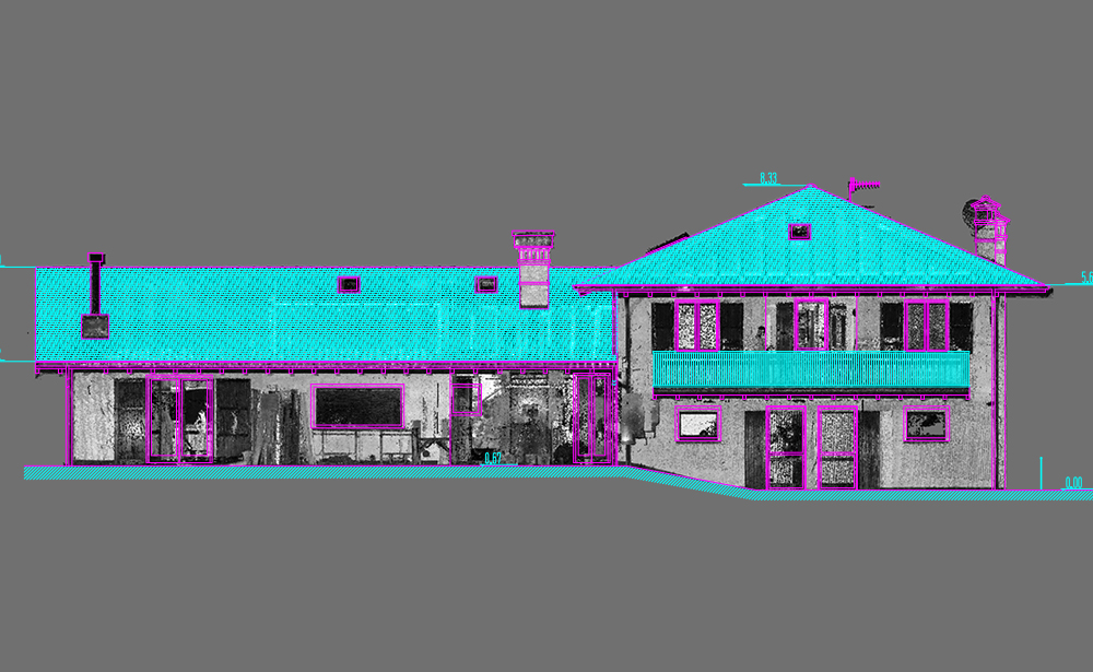
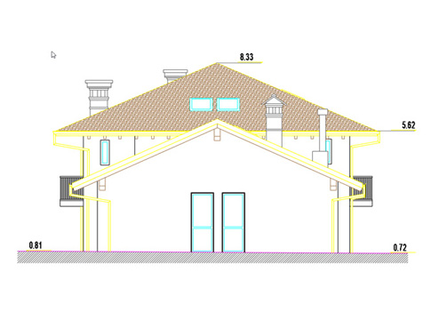
Scan-to-CAD is the process of converting 3D laser scan data (point clouds) into accurate 2D technical drawings, such as floor plans, elevations, and sections. This provides a precise “as-built” record of a building’s current state, which is much more reliable than old paper blueprints.
Our standard deliverables include:
- DWG/DXF Files: Fully layered and scaled AutoCAD files.
- PDF Sets: High-resolution, printable drawing sets.
- Point Cloud Data: We can also provide the processed scan files if you wish to view the 3D data yourself.
Because we draw directly over the point cloud, our accuracy is typically within ±5mm to 15mm, depending on the quality of the scan and the project requirements. This captures real-world conditions, including walls that aren’t perfectly square or floors that have settled.
We offer three standard tiers:
- Schematic: Basic layout showing walls, doors, and windows (ideal for space planning).
- Detailed: Includes fixtures, cabinetry, floor finishes, and basic reflected ceiling plans (RCP).
- Comprehensive: Full architectural detail, including MEP (Mechanical, Electrical, Plumbing) locations, structural elements, and detailed wall thicknesses.
Yes. Unlike traditional hand-measuring, our laser-scan-based workflow allows us to accurately map curved walls, irregular angles, and complex heritage details that are often missed in manual surveys.
We can follow your specific office standards, including layer naming conventions, line weights, and font styles. If you don’t have a specific standard, we use industry-standard AIA (American Institute of Architects) or ISO layering protocols.
Yes. We can align your CAD drawings to a specific site coordinate system or a local survey datum, ensuring that the as-built data integrates perfectly with your site plans and future topographical surveys.
To provide a quote, we need:
- The raw point cloud data (if already scanned) or a site address.
- The total area (sq. meters/sq. feet).
- A list of required drawings (e.g., “Floor plans for levels 1-3 and two cross-sections”).
For a standard commercial or residential space, we typically deliver the first draft within 3 to 5 business days. Larger or more complex industrial sites may take longer, depending on the level of detail required.
Yes. Since our CAD drawings are based on 3D scan data, they serve as an excellent foundation if you decide to upgrade the project to a Revit or ArchiCAD model in the future.
Every project undergoes a rigorous internal review. We overlay the final 2D CAD linework back onto the 3D point cloud to verify that every wall, column, and opening is perfectly aligned with the real-world data.