
In modern architecture, engineering, and construction workflows, precision is no longer optional—it is foundational. One of the most reliable methods for capturing real-world conditions and converting them into usable design data is Scan to CAD (As-Built) modeling. This process bridges the gap between physical structures and digital design environments by transforming laser-scanned data into accurate CAD drawings.
What is Scan to CAD (As-Built)?
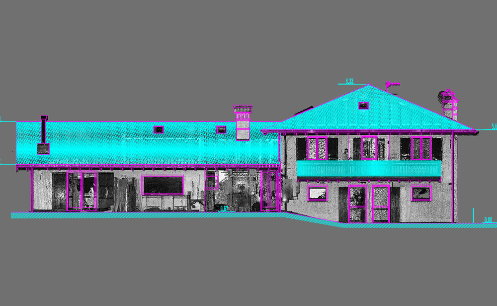
Scan to CAD (As-Built) is the process of capturing existing building conditions using 3D laser scanning (commonly LiDAR or terrestrial scanning) and converting the resulting point cloud data into detailed CAD drawings.
These drawings represent the exact “as-built” state of a structure, including:
- Architectural elements (walls, doors, windows)
- Structural components (beams, columns, slabs)
- MEP systems (HVAC, piping, electrical layouts)
- Site conditions and spatial geometry
Unlike traditional manual measurements, this method provides a highly accurate digital replica of real-world environments.
How the Scan to CAD Process Works
The workflow typically follows four key stages:
1. 3D Laser Scanning
Specialized scanners capture millions of data points from the physical site. This creates a dense point cloud, which represents the structure in 3D space.
2. Point Cloud Registration
Multiple scans are aligned and merged into a single, unified dataset. This ensures consistency and accuracy across the entire project area.
3. CAD Conversion
Technicians or BIM modelers trace and interpret the point cloud data to create 2D CAD drawings or 3D models using software like AutoCAD or similar platforms.
4. Quality Control & Verification
The final CAD drawings are checked against the original scan data to ensure dimensional accuracy and completeness.
Why Scan to CAD (As-Built) Matters
High Accuracy
Laser scanning captures millions of data points, significantly reducing human error compared to manual surveying methods.
Time Efficiency
Large and complex sites can be documented in hours rather than days or weeks.
Cost Reduction
Minimizes rework, design errors, and on-site measurement visits.
Improved Renovation Planning
Existing conditions are clearly documented, making renovations and retrofits more predictable and safer.
Better Collaboration
Architects, engineers, and contractors can work from a shared, reliable digital reference.
Key Applications
Scan to CAD (As-Built) is widely used across multiple industries:
- Architecture: Renovation planning and heritage documentation
- Construction: Site verification and progress tracking
- Industrial Facilities: Plant layout modifications and maintenance planning
- MEP Engineering: System redesign and clash detection
- Real Estate Development: Conversion of old buildings into modern spaces
Scan to CAD vs Traditional Surveying
| Feature | Traditional Surveying | Scan to CAD |
|---|---|---|
| Accuracy | Moderate | Very High |
| Data Density | Limited points | Millions of points |
| Speed | Slower | Faster |
| Risk of Errors | Higher | Minimal |
| Visualization | Basic | Highly detailed |
Challenges in Scan to CAD Projects
While highly effective, the process does have challenges:
- Large data file sizes requiring powerful hardware
- Skilled professionals needed for point cloud interpretation
- Time-intensive manual modeling in complex environments
- Software compatibility across platforms
However, advancements in automation and AI-based modeling are rapidly improving efficiency in this field.
Future of As-Built Documentation
The future of Scan to CAD (As-Built) is closely tied to BIM (Building Information Modeling) and automation technologies. We are moving toward:
- Automated feature recognition from point clouds
- Direct CAD/BIM generation from scan data
- Cloud-based collaboration platforms
- Integration with digital twins for lifecycle management
This evolution will make building documentation faster, more intelligent, and continuously updated.
Conclusion
Scan to CAD (As-Built) has become an essential workflow in today’s AEC industry. It provides an accurate, efficient, and reliable way to document existing conditions and supports better decision-making in design, renovation, and construction projects.